blog: Found footage: making the most of pre-existing data with computer vision
Wednesday 14th February 2024
Do you have a good sense of direction? I do. I don’t know if it’s an innate quality or maybe it’s something I’ve learned over time, but I can find my way around a city pretty well even if I’ve never been there before. Maybe it’s because I spend so much of my time looking at maps – the third most-used app on my phone this week is the maps app (no word of a lie!).
Even with my famous sense of direction, I can’t come into a new city and instantly know how the transport network functions. Don’t know how often the buses run, don’t know where the shared taxis tend to wait for their passengers, don’t know where the cycle lanes are. Even if I’ve lived there for years I still won’t know everything about the city.
That’s fine, that’s why we collect data. I’ve spent countless hours digging through databases, shapefiles and CSVs (and, unfortunately, a fair few blurry PDFs of scanned paper documents from decades past) to get the information we need for the work we are doing.
I am part of ITP’s International Consultancy Team so most of those places are in low and middle income countries (LMICs), and many of them are “data-poor environments”. Depending on the size of the project there are two main options: search around for pre-existing data or, if the budget is large enough to support it, commission surveys to collect the information we need.
Of course there is an important balance to be found – if the data isn’t available we will do our best, but the quality won’t be as high. But if we spend the whole budget on data collection there won’t be any time left to do anything with it!
That’s why I wrote this article – I want to talk about computer vision and how it can cut the cost of data collection. Most importantly, I want to talk about how we could use it to do better transport projects in places where that is currently very difficult – particularly smaller cities in LMICs where data is very sparse.
Computer Vision
I can’t tell you exactly how computer vision works – I’m a transport consultant, not a computer scientist – but I can give you a very high-level description of how we can use it in practice.
Fortunately, this is very simple: you download some computer vision software and input some images, then the software compares the contents of the image against a set of patterns. Each pattern is associated with a “class” – which can be object types (e.g. person, car) or more abstract compositions (e.g. smiling person, day time / night time). If something in the image matches one of these patterns, the software tags it and reports that it has identified the object.
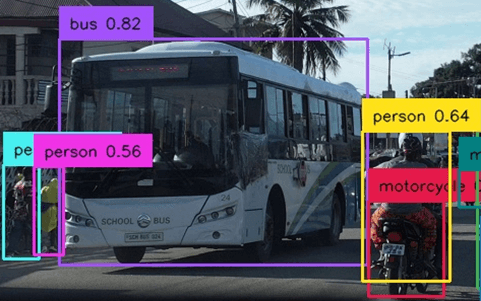
The main benefit for us transport professionals is speed and cost. With a good desktop computer, computer vision systems can process full HD video in real-time and it can run 24/7 with minimal human input, so the main costs are electricity, setting up the camera and configuring the software.
How are we using computer vision at ITP?
With generous support from UKAid from the UK government, through the High Volume Transport programme, we have developed ‘FiveBarGate’: a computer vision tool that produces high level transport data for an entire city, all for a very low cost – just a few staff-hours.

Most simply, this data can be used to gain a quick and intuitive understanding of how people travel in different parts of a city, but more complex insights can be derived with further processing.
For example, by identifying parts of the city with large numbers of both pedestrians and vehicles we can quickly list areas of interest for road safety improvements. With sufficient input data, estimations of mode share are also possible.
Ok this looks pretty cool, but why should I get excited?
The low cost of use for FiveBarGate makes data collection viable for even the smallest budget projects, where traditional data collection methods are just not realistic. The lowest costs can be achieved using free crowdsourced data but, for slightly larger projects, this can be topped up by carrying out targeted surveys using vehicle-mounted cameras. Although this adds the cost of a driver and vehicle for a day, it greatly improves the data quality by allowing the collected images to be targeted for geographic areas and times of day that are most relevant to your project’s needs.
Even better, we can use FiveBarGate to collect data in areas that are less commonly considered for transport development work. Transport authorities in smaller cities in LMICs often do not have the resources to collect data themselves and this acts as a barrier to investment – planning these projects requires data, but collecting data requires some investment to begin. By lowering the cost of data collection, we aim to kickstart the process and make planning transport improvements more viable in more cities around the world.
How else can computer vision be used?
There are a variety of data collection services using computer vision in the UK market alone, such as VivaCity smart traffic monitoring using roadside pole-mounted cameras, Agilysis Global Roads for flows and speeds in rural locations, and Vaisala RoadAI for road maintenance analysis. These examples are all UK-based, because that is where I live, but there are many other services offered in other countries.
There is also a growing market for ‘all in one’ computer vision solutions such as Telraam, which bundles a camera with an AI processing chip, allowing the counting to be performed on the device itself. Although they might not be suitable for all transport projects, these products can be a great starting point for exploring the capabilities of computer vision.
Unfortunately, the current state of computer vision for transport in LMICs is fairly limited – for now. We expect the market to rapidly expand in the coming years and drive down the cost of data collection, making good information more widely available and ultimately making it possible for people get to where they want to go more safely, efficiently and sustainably.
I am a transport professional – how can I make the most of what computer vision has to offer?
1) Think about the data you might need to plan the development work your city needs.
- Is your focus on road safety? Public transport? Walking and cycling? What information would help you address the issues you see?
- Counting people waiting to get on a bus? Estimate the gender ratio of the people walking on a road? Does this neighbourhood have more formal or informal transport?
2) Take an inventory – you could be sitting on a gold mine of data!
- Do you have any cameras in operation already? CCTV on buildings, traffic monitoring cameras, in-vehicle cameras.
- Where is the data stored? How long is it stored for? Are there any legal or institutional policies that might prevent you from using the data? Can these be changed?
3) Talk to us! We are excited to use new technology to Improve the way the world moves. If you have been collecting video we might be able to do something great with it! Contact me at giles.lipscombe@itp.rhdhv.com and we can discuss how to get your project moving!