Creating liveable neighbourhoods, where sustainable mobility is a natural choice for people seeking to access key services, begins with evidence-based land use planning. ITP’s team works extensively with planners, urban designers, and property specialists to create holistic transport strategies that contribute to desirable places, support spatial planning goals, and unlock economic growth.

Local Plans & Infrastructure
- What We Do
- Policy & Strategy
- Local Plans & Infrastructure

By designing-in sustainable transport connections we seek to maximise scope for active travel, while minimising detrimental environmental and social impacts typically associated with people’s need for mobility. In this context strategic land-use development, especially when co-aligned across multiple sites, can create opportunities for game-changing sustainable transport investment.
ITP’s knowledge in this field is wide-ranging. It covers evidence-based preparation of Local Plan transport strategies and assessment of spatial development transport impacts at each stage of the Local Plan process, in line with DCLG guidelines. We also advise property developers on commercial, residential, and regeneration projects.
Capabilities
- Site search and spatial options reviews
- Analysis of transport impacts and socio-demographics
- Transport option appraisal
- Development of Local Plan transport evidence base
- Expert witness services
- Transport Assessments and Travel Plans
- Consultation and stakeholder engagement
Catterick Garrison
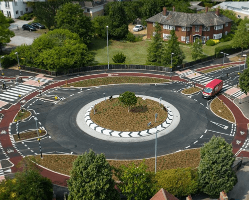
Catterick Garrison is a military town in North Yorkshire which has suffered from unsympathetic planning and the development of big box retail parks that have damaged the original town centre. Working with RegenCo, we applied a Vision and Validate approach that envisaged how growth could be used to revitalise the town centre and then what measures would be needed to deliver it. We reimagined the currently car dominated routes into the town centre and developed a package of transformational highway and public realm improvements focused on place making and encouraging more walking, cycling and use of public transport. This package drew on our experience of applying Dutch best practice to the UK. Accompanying this we developed a connectivity strategy for the whole town that sought to better connect existing residents and the military barracks to key destinations across the town. The work culminated in the development of a masterplan for the town centre, led by Tibbalds and SQW.
Image Source: Leon Neal
Portsmouth Local Transport Plan
Portsmouth is a city with significant ambitions. It has a growing population and the Council has committed to making the city carbon neutral by 2030. A core part of accommodating growth, while making the city a better place to live and easier to travel around, will be its new Local Transport Plan.
Our plan includes re-prioritising road space on strategic routes into the city centre for segregated Bus Rapid Transit and Cycle Superhighway routes, significantly reducing the quantum of on-street and off-street parking and delivering an expanded Park & Ride.
We are also reimagining local neighbourhoods through the introduction of filtered permeability for walking and cycling, severing ‘rat-runs’ and introducing on-street EV charging, cycle storage and active play facilities in line with the Healthy Streets approach.
Image source: AHG

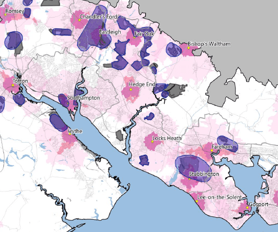
South Hampshire Strategic Growth Study
The Partnership for South Hampshire (PfSH) contains twelve local authorities in the Solent region. PfSH commissioned ITP to review Strategic Development Opportunity Areas (SDOA) totalling over 100,000 homes to help inform the evidence base for a Joint Spatial Plan between the authorities. We applied our Vision and Validate approach to this work, agreeing a transparent decision-making framework for SDOA selection that prioritises sites that can deliver higher levels of walking, cycling and public transport. Based on a detailed spatial analysis of the existing network and movement patterns and drawing from our Transport Measures Toolkit, we then applied our Mode Shift Model to each SDOA to develop a set of bespoke trip rates. We worked with Solent Transport’s modelling team to reimagine the role of modelling to deliver a ‘Vision and Validate’ approach to forecasting to inform decision-making on how to allocate growth across the region.
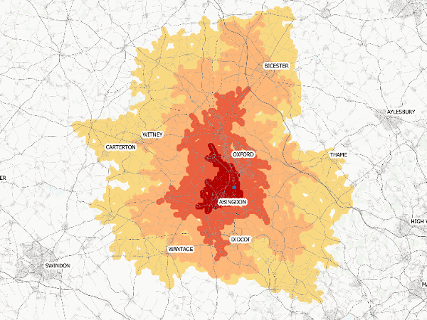
Oxfordshire Transport Infrastructure Framework & Spatial Options
ITP assisted Oxfordshire County Council and the five District Council Planning Authorities in the County (including Oxford City Council) with development of a Transport Infrastructure Framework to support forecast housing and employment growth, including a portion of unmet housing need identified by Oxford City. Our strategic advice helped the County Council to prioritise transport improvements and inform collaborative decision-making with the planning authorities on optimal combinations of spatial options that can be supported through Local Plan processes. The output of this work was a Transport Infrastructure Framework, developed by ITP, which helped the planning authorities to arrive at an equitable apportionment of settlements to accommodate Oxford City's unmet housing need, and provides a robust evidence base for future transport infrastructure investment proposals to underpin future Local Plan soundness tests.

South West Hertfordshire Multi Modal Strategy
We are helping the District and County Councils for South West Herts develop the evidence base for a Joint Statutory Spatial Plan that will deliver 125,000 new homes by 2050. Working alongside David Lock Associates we are identifying the potential growth locations that will deliver these new homes and the associated employment growth.
With a focus on ensuring sustainable travel we have analysed existing movement patterns to identify the potential mode shift for existing residents as well as how growth could drive the demand for new rapid transit, walking and cycling connections and fund their implementation.
Our Multi Modal Strategy, alongside DLA’s Strategic Growth Location Study, will be a core part of the evidence base for the forthcoming Joint Spatial Plan.
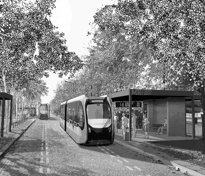
Milton Keynes Mass Rapid Transit
Milton Keynes Council has an aspiration to double the city's population to 500,000 by 2050 - effectively delivering another New Town around the existing communities, while reimagining the 1960s infrastructure networks. Our work developed proposals for a new Mass Rapid Transit network, drawing on precedents from the UK and Europe and included routeing, vehicle type, service patterns, demand forecasting, costing and viability. Alongside David Lock Associates, we helped identify growth options to deliver transformational change to existing communities and unlock ‘good growth’.
Our outputs included a costed Mass Rapid Transit network, a high-level cost benefit appraisal and recommendations regarding phasing, supporting infrastructure and policy. This, alongside recommendations on growth options, has informed the Milton Keynes Strategy for 2050. We have subsequently undertaken a review of the original strategy in the light of the COVID pandemic to stress test the network against a range of possible post-pandemic scenarios.
Image source: David Lock Associates

Black Country Joint Core Strategy
The Black Country Core Strategy was the spatial planning document developed in partnership by the sub-region’s four local authorities (Dudley, Sandwell, Walsall and Wolverhampton). It was the largest development plan of its kind in the UK, affecting over 1.2 million people; setting out the vision, objectives, and strategy for future development across the Black Country to 2026.
ITP’s role was to provide technical expertise on transport grounds; presenting the case for extensive investment in the transport network to support regional economic regeneration, and local growth, at an Examination in Public. Our assured and professional approach helped ensure the adoption of a sound Plan in 2011, resulting in the Black Country Joint Core Strategy Team, including ITP, being awarded the ‘2011 Team of the Year’ accolade by the West Midlands Royal Town Planning Institute.
Wolverhampton City Centre Area Action Plan
ITP compiled the evidence base to underpin the transport strategy associated with three discrete Area Action Plans in Wolverhampton: the City Centre, Bilston Road corridor and Stafford Road corridor. The work involved the collation and analysis of diverse and extensive transport and socio-demographic data sets to illustrate the key transport challenges across the AAP areas and making recommendations regarding how these challenges are best resolved.
The evidence base output was intentionally designed as a quick reference document that can be drawn upon by officers from Wolverhampton City Council through the course of developing the individual AAP transport strategies, as well as any future Examination in Public.